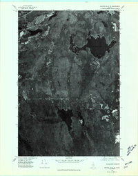
1975 Map of Smyrna Mills SE
USGS Topo · Published 1980About this map
Meduxnekeag Lake dominates the northeastern portion of this mid-1970s orthophotograph, its irregular shoreline and dark waters contrasting sharply with the surrounding Maine forest. This U.S. Geological Survey sheet provides a photographic perspective of the North Woods, where the landscape is defined more by its terrain and hydrology than by human settlement. Further south, the waters of Skitaccooke Lake appear alongside a grid of timberlands and localized clearings. Significant elevations like Timoney Mountain and Sam Drew Mountain rise above the basin, while Bates Ridge marks the higher ground to the east. This specific orthophoto series was prepared from aerial imagery captured on May 25, 1975, providing researchers with a clear visual record of vegetation patterns and undeveloped land use in Aroostook County prior to modern developments.
Find a feature on this map
5 named features on this map. Tap any name to fly to it.
Don’t see what you’re looking for? This feature index may not catch every label — zoom into the map to look around manually.
Map Details
Editions of this 1975 Smyrna Mills SE Map
This is the sole edition of this map. No revisions or reprints were ever made.
Other maps of this area

1937 · Smyrna Mills
USGS Topo · 1:62,500

1938 · Houlton
USGS Topo · 1:62,500

1940 · Amity
USGS Topo · 1:62,500

1941 · Amity
USGS Topo · 1:62,500

1941 · Mattawamkeag Lake
USGS Topo · 1:62,500

1943 · Amity
USGS Topo · 1:62,500

1943 · Mattawamkeag Lake
USGS Topo · 1:62,500

1951 · Houlton
USGS Topo · 1:62,500

1954 · Presque Isle
USGS Topo · 1:250,000

1954 · Millinocket
USGS Topo · 1:250,000