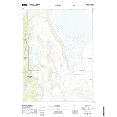
2018 Map of Snake Lake
USGS Topo · Published 2018About this map
The high desert landscape of Surprise Valley and the eastern edge of Modoc National Forest define this 2018 survey on the California-Nevada border. Water management is a central theme of this arid region, as evidenced by the engineering of the Bare Cr Ditch and the containment of the Sworinger Reservoir. The hydrology of the area transitions from the seasonal waters of Lower Lake and Snake Lake to the rugged drainage systems of Waterbox Canyon and Snowslide Canyon. A network of unpaved transit routes, including Surprise Valley Rd and Co RD 42, provides the primary access through these remote forest and basin lands. Local landmarks like Van Riper Spring and the headwaters of Silver Cr offer specific points of interest for those tracking the historical use of water resources in this tri-county corner of Modoc, Lassen, and Washoe counties.
Find a feature on this map
23 named features on this map. Tap any name to fly to it.
Don’t see what you’re looking for? This feature index may not catch every label — zoom into the map to look around manually.
Map Details
Editions of this 2018 Snake Lake Map
This is the sole edition of this map. No revisions or reprints were ever made.
Other maps of this area

1886 · Alturas
USGS Topo · 1:250,000

1889 · Long Valley
USGS Topo · 1:250,000

1892 · Alturas
USGS Topo · 1:250,000

1954 · Vya
USGS Topo · 1:250,000

1954 · Alturas
USGS Topo · 1:250,000

1958 · Alturas
USGS Topo · 1:250,000

1958 · Vya
USGS Topo · 1:250,000

1962 · Alturas
USGS Topo · 1:250,000

1962 · Vya
USGS Topo · 1:250,000

1962 · Snake Lake
USGS Topo · 1:24,000