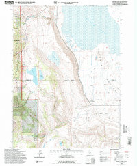
1993 Map of Snake Lake
USGS Topo · Published 1996About this map
The Warner Mountains dominate the western horizon of this survey, where the South Warner Wilderness and Modoc National Forest preserve a landscape of steep canyons and high peaks like Hat Mountain. To the east, the terrain drops sharply into the Surprise Valley, a contrasting expanse of flat basin floor characterized by alkaline waters and seasonal drainage systems. This transition is marked by the presence of Bare Ranch, a significant local landmark that includes the Bare Ranch Airport and an extensive irrigation network including the Bare Creek Ditch. Hydrological patterns are central to the area's character, from the high-elevation Snake Lake and Sworinger Reservoir to the vast, shallow reaches of Lower Lake in the valley basin. The map captures a moment of managed ranching and wilderness preservation, where drainages like Silver Creek and Barber Creek descend from the forest into the arid valley below.
Find a feature on this map
23 named features on this map. Tap any name to fly to it.
Don’t see what you’re looking for? This feature index may not catch every label — zoom into the map to look around manually.
Map Details
Editions of this 1993 Snake Lake Map
This is the sole edition of this map. No revisions or reprints were ever made.
Other maps of this area

1886 · Alturas
USGS Topo · 1:250,000

1889 · Long Valley
USGS Topo · 1:250,000

1892 · Alturas
USGS Topo · 1:250,000

1954 · Vya
USGS Topo · 1:250,000

1954 · Alturas
USGS Topo · 1:250,000

1958 · Alturas
USGS Topo · 1:250,000

1958 · Vya
USGS Topo · 1:250,000

1962 · Alturas
USGS Topo · 1:250,000

1962 · Vya
USGS Topo · 1:250,000

1962 · Snake Lake
USGS Topo · 1:24,000