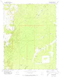
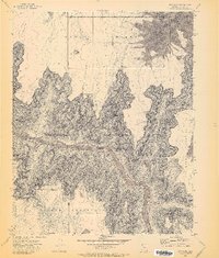
1971 Map of Snap Draw
USGS Topo · Published 1974About this map
Grand Wash and the dramatic verticality of the Cliffs dominate this arid portion of Mohave County as it appeared in the early 1970s. This landscape is defined by its drainage systems and water security, with deep-cut features like Snap Canyon and Gardner Canyon directing the seasonal flow of Snap Draw. The presence of small-scale mining activity is evident near the head of Snap Canyon, where a Mine and a Prospect are marked adjacent to Snap Spring. Human presence is largely represented by infrastructure designed for livestock and land management, including numerous water catchments such as Tincanebitts Tank, Gardner Tank, and the distinctive Lower Salt House Tank located along Salt House Draw. A network of Jeep Trails provides the only access through this dissected terrain, connecting remote points like Mustang Point and Blanco to the wider region.
Find a feature on this map
21 named features on this map. Tap any name to fly to it.
Don’t see what you’re looking for? This feature index may not catch every label — zoom into the map to look around manually.
Map Details
Editions of this 1971 Snap Draw Map
This is the sole edition of this map. No revisions or reprints were ever made.
Other maps of this area

1886 · Mt. Trumbull
USGS Topo · 1:250,000

1892 · Mt. Trumbull
USGS Topo · 1:250,000

1953 · Grand Canyon
USGS Topo · 1:250,000

1957 · Grand Canyon
USGS Topo · 1:250,000

1958 · Grand Canyon
USGS Topo · 1:250,000

1960 · Grand Canyon
USGS Topo · 1:250,000
1971 · Castle Peak
USGS Topo · 1:24,000
1971 · Mt. Dellenbaugh
USGS Topo · 1:24,000
1971 · Wildcat Ranch
USGS Topo · 1:24,000
1971 · Bat Cave
USGS Topo · 1:24,000