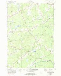
1981 Map of Snow Mountain
USGS Topo · Published 1982About this map
The rolling interior of Penobscot and Waldo Counties is defined by a network of crossroads settlements and family-named landmarks. The landscape features prominent high points such as Snow Mountain and Pickard Hill, separated by a complex drainage system including Souadabscook Stream and Marsh Stream. In the southern reaches, the Bangor and Aroostook railroad line cuts through the terrain near the Winterport Sta, marking the era's transport corridor. Local history is etched into the map at several small burial grounds like Chapman Cem and Twining Cem, while the agrarian and residential character of the late 1970s is evident in the transition from active farms to wooded hills. The presence of an Abandoned Airfield near the Winterport border hints at shifting land use, while small community hubs like Newburgh Village and Ellingwood Corner serve as the primary anchors for the surrounding rural population.
Find a feature on this map
52 named features on this map. Tap any name to fly to it.
Don’t see what you’re looking for? This feature index may not catch every label — zoom into the map to look around manually.
Map Details
Editions of this 1981 Snow Mountain Map
This is the sole edition of this map. No revisions or reprints were ever made.
Other maps of this area

1900 · Bucksport
USGS Topo · 1:62,500

1902 · Bucksport
USGS Topo · 1:62,500

1902 · Bangor
USGS Topo · 1:62,500

1931 · Stetson
USGS Topo · 1:48,000

1932 · Brooks
USGS Topo · 1:62,500

1935 · Stetson
USGS Topo · 1:62,500

1942 · Bangor
USGS Topo · 1:62,500

1942 · Bucksport
USGS Topo · 1:62,500

1946 · Bangor
USGS Topo · 1:62,500

1948 · Bangor
USGS Topo · 1:250,000