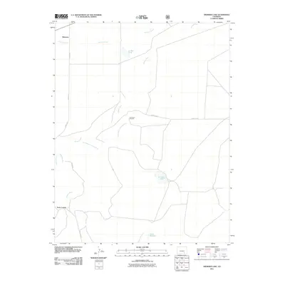
2011 Map of Snowden Lake
USGS Topo · Published 2011About this map
Whiterock and the surrounding high plains of Pueblo County appear here in a landscape defined by seasonal watercourses and ranching infrastructure. The Apishapa River winds through the center of the quadrangle, flanked by its Old Channel and the dry beds of Saunders Arroyo and Buffalo Arroyo. This 2011 survey reveals how water management is central to the area's utility, marked by features such as Snowden Lake, La Pear Pond, and Hixon Reservoir. The network of functional landmarks, including the Bull Pasture Windmill and the specifically noted Rock Crossing, indicates a long-standing reliance on these specific points for navigating the prairie. Roadways like Flying A Rd and Whiterock Rd provide the primary access to this sparse ranching territory, where Kitch Spring remains a notable natural water source in an otherwise arid environment.
Find a feature on this map
15 named features on this map. Tap any name to fly to it.
Don’t see what you’re looking for? This feature index may not catch every label — zoom into the map to look around manually.
Map Details
Editions of this 2011 Snowden Lake Map
This is the sole edition of this map. No revisions or reprints were ever made.
Other maps of this area

1891 · Timpas
USGS Topo · 1:125,000

1891 · Apishapa
USGS Topo · 1:125,000

1893 · Apishapa
USGS Topo · 1:125,000

1894 · Timpas
USGS Topo · 1:125,000

1897 · Apishapa
USGS Topo · 1:125,000

1954 · Trinidad
USGS Topo · 1:250,000

1955 · La Junta
USGS Topo · 1:250,000

1955 · Trinidad
USGS Topo · 1:250,000

1958 · La Junta
USGS Topo · 1:250,000

1958 · Trinidad
USGS Topo · 1:250,000