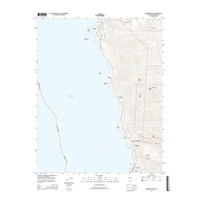
2015 Map of Soberanes Point
USGS Topo · Published 2015About this map
Santa Lucia Range peaks meet the Pacific Ocean along this dramatic stretch of the Monterey County coast. The topography is defined by sharp elevation changes, where steep ridges like Portuguese Ridge and summits such as Cushing Mtn drop toward a coastline of named points and breakers. The drainage pattern is dense, with Garrapata Cr, Malpaso Cr, and Wildcat Cr cutting deep canyons into the mountain front. Settlement is concentrated at Yankee Point in the north, with its network of residential roads like Spindrift Rd and Mentone Rd, while the southern reaches remain more open around the site of Notleys Landing. This survey details the complex interface of land and sea at Soberanes Point, where offshore features like Lobos Rock and Yankee Point Breaker signal the hazards of the nearshore environment.
Find a feature on this map
44 named features on this map. Tap any name to fly to it.
Don’t see what you’re looking for? This feature index may not catch every label — zoom into the map to look around manually.
Map Details
Editions of this 2015 Soberanes Point Map
This is the sole edition of this map. No revisions or reprints were ever made.
Other maps of this area

1913 · Monterey
USGS Topo · 1:62,500

1918 · Point Sur
USGS Topo · 1:62,500

1925 · Point Sur
USGS Topo · 1:62,500

1941 · Monterey
USGS Topo · 1:62,500

1947 · Point Sur
USGS Topo · 1:62,500

1947 · Seaside
USGS Topo · 1:24,000

1947 · Monterey
USGS Topo · 1:62,500

1947 · Monterey
USGS Topo · 1:24,000

1948 · Santa Cruz
USGS Topo · 1:250,000
1948 · Seaside
USGS Topo · 1:24,000