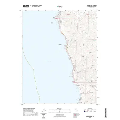
2018 Map of Soberanes Point
USGS Topo · Published 2018About this map
Yankee Point and the steep slopes of the Santa Lucia Range define this coastal interface where the land drops precipitously into the Pacific Ocean. This 2018 survey reveals a landscape largely shaped by its dramatic verticality, with named peaks like Whale Peak and Puerta del Diablo standing above deep-cut drainages such as Wildcat Canyon and Granite Canyon. The network of trails, including the Soberanes Point Trl and Rocky Ridge Trl, suggests a region dedicated to coastal access and conservation. Transportation is funneled along the narrow corridor of Coast Rd, while more isolated roads like Palo Colorado Rd and Garrapata Trout Farm Rd push eastward into the ridges. The map meticulously labels the jagged shoreline features, from Yankee Point Rock in the north to Rocky Point further south, illustrating the numerous creeks like Malpaso Cr and Garrapata Cr that have carved the coastal terrace.
Find a feature on this map
54 named features on this map. Tap any name to fly to it.
Don’t see what you’re looking for? This feature index may not catch every label — zoom into the map to look around manually.
Map Details
Editions of this 2018 Soberanes Point Map
This is the sole edition of this map. No revisions or reprints were ever made.
Other maps of this area

1913 · Monterey
USGS Topo · 1:62,500

1918 · Point Sur
USGS Topo · 1:62,500

1925 · Point Sur
USGS Topo · 1:62,500

1941 · Monterey
USGS Topo · 1:62,500

1947 · Point Sur
USGS Topo · 1:62,500

1947 · Seaside
USGS Topo · 1:24,000

1947 · Monterey
USGS Topo · 1:62,500

1947 · Monterey
USGS Topo · 1:24,000

1948 · Santa Cruz
USGS Topo · 1:250,000
1948 · Seaside
USGS Topo · 1:24,000