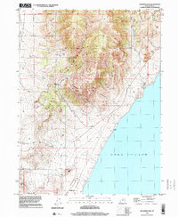
1997 Map of Soldiers Pass
USGS Topo · Published 2001About this map
The Lake Mountains rise sharply between the Cedar Valley and the western shores of Utah Lake in this 1997 topographical study. The landscape is defined by its deep drainage networks and mining history, with numerous prospects, a claypit, and various gravel pits dotting the ridges. The eastern slope is particularly complex, featuring named geographic landmarks like Hells Kitchen, Miners Ridge, and Enoch Divide that lead down toward the water.
Find a feature on this map
38 named features on this map. Tap any name to fly to it.
Don’t see what you’re looking for? This feature index may not catch every label — zoom into the map to look around manually.
Map Details
Editions of this 1997 Soldiers Pass Map
This is the sole edition of this map. No revisions or reprints were ever made.
Other maps of this area

1885 · Salt Lake
USGS Topo · 1:250,000

1885 · Tooele Valley
USGS Topo · 1:250,000

1915 · Fairfield
USGS Topo · 1:62,500

1917 · Fairfield
USGS Topo · 1:62,500

1947 · Fivemile Pass
USGS Topo · 1:62,500

1947 · Allens Ranch
USGS Topo · 1:24,000

1947 · Goshen Pass
USGS Topo · 1:24,000

1949 · Allens Ranch
USGS Topo · 1:24,000

1949 · Goshen Pass
USGS Topo · 1:24,000

1950 · West Mountain
USGS Topo · 1:24,000