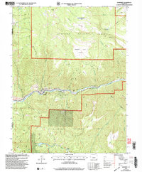
2001 Map of Somerset
USGS Topo · Published 2004About this map
Somerset serves as the industrial and residential hub for this stretch of the North Fork Gunnison River, where the landscape is defined by the extraction and transport of coal. A dense concentration of mining operations, including the Kaiser Mine, Bear Mine, and Arco Mine, lines the northern bank of the river, utilizing the steep terrain for infrastructure. These sites are linked by infrastructure such as the Fire Mountain Canal and specialized facilities like the Gaging Station and a Communication Site.
Find a feature on this map
47 named features on this map. Tap any name to fly to it.
Don’t see what you’re looking for? This feature index may not catch every label — zoom into the map to look around manually.
Map Details
Editions of this 2001 Somerset Map
This is the sole edition of this map. No revisions or reprints were ever made.
Other maps of this area

1938 · Mt. Gunnison
USGS Topo · 1:48,000

1945 · Mount Gunnison
USGS Topo · 1:62,500

1956 · Montrose
USGS Topo · 1:250,000

1957 · Leadville
USGS Topo · 1:250,000

1959 · Leadville
USGS Topo · 1:250,000

1959 · Montrose
USGS Topo · 1:250,000

1960 · Leadville
USGS Topo · 1:250,000

1960 · Montrose
USGS Topo · 1:250,000

1961 · Electric Mountain
USGS Topo · 1:24,000

1962 · Leadville
USGS Topo · 1:250,000