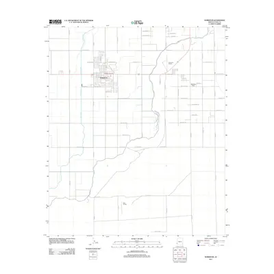
2011 Map of Somerton
USGS Topo · Published 2011About this map
Somerton serves as the central hub of this agricultural landscape in Yuma County, organized around a rigid grid of irrigation and transport. The Main Drain runs north-south through the western territory, a critical component of the local water management system that sustains the surrounding fields. Transportation and aviation are prominent, with the Somerton Airport and Rolle Airfield providing local infrastructure, while Hwy-95 acts as the primary arterial road connecting the town to the broader region.
Find a feature on this map
43 named features on this map. Tap any name to fly to it.
Don’t see what you’re looking for? This feature index may not catch every label — zoom into the map to look around manually.
Map Details
Editions of this 2011 Somerton Map
This is the sole edition of this map. No revisions or reprints were ever made.
Other maps of this area

1903 · Yuma
USGS Topo · 1:125,000

1905 · Yuma
USGS Topo · 1:125,000

1940 · Yuma
USGS Topo · 1:62,500

1942 · Yuma
USGS Topo · 1:250,000

1945 · Yuma
USGS Topo · 1:62,500

1952 · Yuma East
USGS Topo · 1:24,000

1952 · Yuma West
USGS Topo · 1:24,000
1953 · Grays Well NE
USGS Topo · 1:24,000

1954 · El Centro
USGS Topo · 1:250,000

1955 · El Centro
USGS Topo · 1:250,000