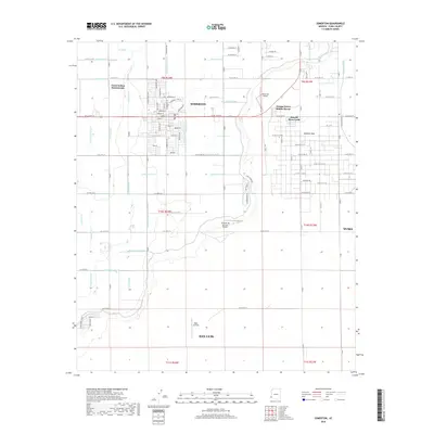
2018 Map of Somerton
USGS Topo · Published 2018About this map
Somerton serves as the focal point of this agricultural corridor in southern Yuma County, surrounded by an intricate network of irrigation infrastructure essential to the desert valley. The landscape is defined by its rectilinear grid of laterals and drains, including the Somerton Lateral and Bondesson Lateral, which divert water to sustain the surrounding fields. The influence of the Colorado River's floodplain is evident in the presence of the Yuma Indian Homesteads and the sprawling water management system of the Main Drain and Central Canal.
Find a feature on this map
85 named features on this map. Tap any name to fly to it.
Don’t see what you’re looking for? This feature index may not catch every label — zoom into the map to look around manually.
Map Details
Editions of this 2018 Somerton Map
This is the sole edition of this map. No revisions or reprints were ever made.
Other maps of this area

1903 · Yuma
USGS Topo · 1:125,000

1905 · Yuma
USGS Topo · 1:125,000

1940 · Yuma
USGS Topo · 1:62,500

1942 · Yuma
USGS Topo · 1:250,000

1945 · Yuma
USGS Topo · 1:62,500

1952 · Yuma East
USGS Topo · 1:24,000

1952 · Yuma West
USGS Topo · 1:24,000
1953 · Grays Well NE
USGS Topo · 1:24,000

1954 · El Centro
USGS Topo · 1:250,000

1955 · El Centro
USGS Topo · 1:250,000