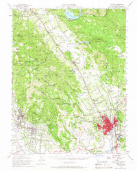
1951 Map of Sonoma
USGS Topo · Published 1966About this map
Vineyard-rich valleys and prominent volcanic peaks characterize this mid-century survey of the California wine country. The Napa River serves as the central artery, flanked by the Southern Pacific railroad and the Silverado Trail, connecting established agricultural hubs from St Helena and Rutherford down to Yountville and the expanding city of Napa. The map captures a landscape transitioning between its deep pioneer roots and modern development, evidenced by the presence of institutions like the Napa State Hospital, the State Veterans Home, and the Vallejo Home State Historic Monument. In the higher elevations of the Napa and Sonoma county line, the terrain is marked by family-named schools and remote landmarks such as the La Joya Mine and Napa Soda Springs. Small rural clusters like Vineburg and Agua Caliente highlight the local mineral springs and early resort culture of the Sonoma area.
Find a feature on this map
132 named features on this map. Tap any name to fly to it.
Don’t see what you’re looking for? This feature index may not catch every label — zoom into the map to look around manually.
Map Details
Editions of this 1951 Sonoma Map
3 editions found
Other maps of this area

1896 · Carquinez Strait
USGS Topo · 1:62,500

1898 · Karquines
USGS Topo · 1:62,500

1901 · Karquines
USGS Topo · 1:62,500

1902 · Napa
USGS Topo · 1:125,000

1914 · Petaluma
USGS Topo · 1:62,500

1916 · Mare Island
USGS Topo · 1:62,500

1916 · Santa Rosa
USGS Topo · 1:62,500

1921 · Mt. Vaca
USGS Topo · 1:62,500

1924 · Capay
USGS Topo · 1:62,500

1927 · Calistoga
USGS Topo · 1:62,500