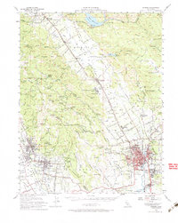
1951 Map of Sonoma
USGS Topo · Published 1984About this map
The Napa River valley and the surrounding hills of Sonoma and Napa counties appear here during a period of established viticulture and civic growth. The landscape is defined by its historic land grants, such as Carne Humana and Huichica, which still influenced the property lines and road layouts of the mid-20th century. Major institutional landmarks anchor the region, including the State Veterans Home near Yountville and the sprawling Napa State Hospital at Imola.
Find a feature on this map
98 named features on this map. Tap any name to fly to it.
Don’t see what you’re looking for? This feature index may not catch every label — zoom into the map to look around manually.
Map Details
Editions of this 1951 Sonoma Map
3 editions found
Other maps of this area

1896 · Carquinez Strait
USGS Topo · 1:62,500

1898 · Karquines
USGS Topo · 1:62,500

1901 · Karquines
USGS Topo · 1:62,500

1902 · Napa
USGS Topo · 1:125,000

1914 · Petaluma
USGS Topo · 1:62,500

1916 · Mare Island
USGS Topo · 1:62,500

1916 · Santa Rosa
USGS Topo · 1:62,500

1921 · Mt. Vaca
USGS Topo · 1:62,500

1924 · Capay
USGS Topo · 1:62,500

1927 · Calistoga
USGS Topo · 1:62,500