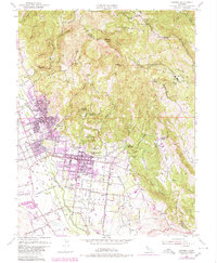
1951 Map of Sonoma
USGS Topo · Published 1980About this map
The Vallejo Home State Historical Monument and the historic street grid of Sonoma anchor this study of the Valley of the Moon as it transitioned from an agricultural center to a growing residential and viticultural hub. The map highlights the early development of the region's famed springs, including Fetters Hot Springs and Boyes Hot Springs, along with the legendary Buena Vista Wine Cellars east of the city. The Northwestern Pacific railroad corridor and the Pueblo Lands boundaries reflect the area's complex land grant history and its reliance on rail transport for both industry and early tourism. Local life is documented through features like the Mountain Cem, Sassarini Sch, and the cluster of activity at Four Corners. From the orchards of Vineburg to the elevated reaches of Hogback Mtn, the map preserves a detailed record of the landscape before significant modern expansion.
Find a feature on this map
66 named features on this map. Tap any name to fly to it.
Don’t see what you’re looking for? This feature index may not catch every label — zoom into the map to look around manually.
Map Details
Editions of this 1951 Sonoma Map
4 editions found
Other maps of this area

1902 · Napa
USGS Topo · 1:125,000

1914 · Petaluma
USGS Topo · 1:62,500

1916 · Mare Island
USGS Topo · 1:62,500

1916 · Santa Rosa
USGS Topo · 1:62,500

1942 · Mare Island
USGS Topo · 1:62,500

1942 · Sonoma
USGS Topo · 1:62,500

1942 · Petaluma
USGS Topo · 1:62,500

1944 · Santa Rosa
USGS Topo · 1:62,500

1947 · Santa Rosa
USGS Topo · 1:250,000

1949 · Santa Rosa
USGS Topo · 1:250,000