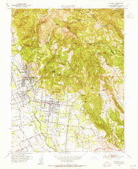
1951 Map of Sonoma
USGS Topo · Published 1955About this map
Sonoma sits at the heart of the valley floor, surrounded by the Pueblo Lands and a landscape transitioning from agricultural vine plantations to mid-century residential expansion. This 1951 survey records the historical significance of the region, identifying the Vallejo Home State Historical Monument and the Mission San Francisco Solano Vineyard. Along the western edge of the valley, the thermal resort culture is evident through a string of settlements including Agua Caliente, Fetters Hot Springs, and Boyes Hot Springs. The map also captures the evolving transportation network, showing the Northwestern Pacific RR line and a Dismantled RR route that hints at earlier transit patterns. Education and industry are well-marked, from the Mount La Salle School in the eastern hills to several Quarries and a Gravel Pit near Verano. The rugged eastern backdrop is defined by Bismarck Knob and Hogback Mtn, where steep canyons like Redwood Canyon descend toward the fertile valley floor.
Find a feature on this map
80 named features on this map. Tap any name to fly to it.
Don’t see what you’re looking for? This feature index may not catch every label — zoom into the map to look around manually.
Map Details
Editions of this 1951 Sonoma Map
4 editions found
Other maps of this area

1902 · Napa
USGS Topo · 1:125,000

1914 · Petaluma
USGS Topo · 1:62,500

1916 · Mare Island
USGS Topo · 1:62,500

1916 · Santa Rosa
USGS Topo · 1:62,500

1942 · Mare Island
USGS Topo · 1:62,500

1942 · Sonoma
USGS Topo · 1:62,500

1942 · Petaluma
USGS Topo · 1:62,500

1944 · Santa Rosa
USGS Topo · 1:62,500

1947 · Santa Rosa
USGS Topo · 1:250,000

1949 · Santa Rosa
USGS Topo · 1:250,000