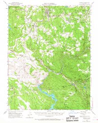
1948 Map of Sonora
USGS Topo · Published 1967About this map
Gold Country mining operations and the growing infrastructure of the Tuolumne River watershed define this late 1940s landscape. The Sierra RR winds through the northern hills, connecting Jamestown and Sonora while passing historic extraction sites like the Harvard Mine and Golden Rule Mine. This era shows the critical role of water management in the Sierra foothills, with the Hetch Hetchy Aqueduct cutting across the terrain near the Don Pedro Reservoir. The map documents numerous family-named landmarks and small community hubs, including Chinese Camp and Jacksonville, alongside remote educational and religious sites like Wards Ferry Sch and Morgan Chapel. From the Red Hills to the depths of the Tuolumne River canyon, the topography reflects a region transitioning from its pioneer mining roots to becoming a vital corridor for California's mid-century water and timber needs.
Find a feature on this map
112 named features on this map. Tap any name to fly to it.
Don’t see what you’re looking for? This feature index may not catch every label — zoom into the map to look around manually.
Map Details
Editions of this 1948 Sonora Map
2 editions found
Other maps of this area

1889 · Jackson
USGS Topo · 1:125,000

1891 · Big Trees
USGS Topo · 1:125,000

1892 · Jackson
USGS Topo · 1:125,000

1893 · Sonora
USGS Topo · 1:125,000

1894 · Big Trees
USGS Topo · 1:125,000

1896 · Sonora
USGS Topo · 1:125,000

1897 · Jackson
USGS Topo · 1:125,000

1897 · Sonora
USGS Topo · 1:125,000

1897 · Big Trees
USGS Topo · 1:125,000

1898 · Sonora
USGS Topo · 1:125,000