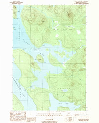
1989 Map of Soper Mountain
USGS Topo · Published 1989About this map
Allagash Wilderness State Waterway defines the character of this northern Maine landscape, protecting a vast network of interconnected lakes and rivers. Centered on Eagle Lake and the northern reaches of Chamberlain Lake, the map documents a remote interior focused on water-based travel and resource management. The presence of an Old Railroad Grade near the southern boundary provides evidence of earlier industrial activities, likely related to the timber trade that historically dominated this region. Numerous primitive sites such as Pillsbury Island Campsite and Thoreau Campsite are scattered along the shorelines, while prominent terrain features like Soper Mountain and Dunphy Ridge provide significant elevation above the valleys of Soper Brook and Bog Brook.
Find a feature on this map
31 named features on this map. Tap any name to fly to it.
Don’t see what you’re looking for? This feature index may not catch every label — zoom into the map to look around manually.
Map Details
Editions of this 1989 Soper Mountain Map
This is the sole edition of this map. No revisions or reprints were ever made.
Other maps of this area

1953 · Telos Lake
USGS Topo · 1:62,500

1954 · Chesuncook
USGS Topo · 1:62,500

1954 · Spider Lake
USGS Topo · 1:62,500

1954 · Churchill Lake
USGS Topo · 1:62,500

1954 · Presque Isle
USGS Topo · 1:250,000

1957 · Telos Lake
USGS Topo · 1:62,500

1958 · Presque Isle
USGS Topo · 1:250,000

1958 · Chesuncook
USGS Topo · 1:62,500

1960 · Presque Isle
USGS Topo · 1:250,000

1961 · Spider Lake
USGS Topo · 1:62,500
Featured Places
- T7 R13 WELS, ME
- Eagle Lake Township, ME
- Soper Mountain Township, ME
- T7 R12 WELS, ME
- Piscataquis County, ME