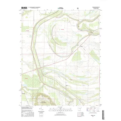
2017 Map of Soudan
USGS Topo · Published 2017About this map
The confluence of the Saint Francis River and L'Anguille River shapes this corner of eastern Arkansas, where the alluvial plain meets the distinct elevation of Crowley Ridge. The settlement of Soudan is marked by the Soudan Cem, positioned near a sharp bend in the river system. This landscape is a complex network of oxbow lakes and wetlands, including Little Yancopin Lake, Big Yancopin Lake, and Larkin Lake, which illustrate the historical movement of these watercourses. To the south, the topography shifts upward at Skidmore Ridge as it enters the St. Francis National Forest. The map captures the specialized water management infrastructure of the Madison-Marianna Diversion, essential for controlling the seasonal shifts of these major delta rivers. Near the community of Cody, river features like True Love Bar and Cow Bayou Bar indicate the active depositional environment of the Saint Francis during this period.
Find a feature on this map
47 named features on this map. Tap any name to fly to it.
Don’t see what you’re looking for? This feature index may not catch every label — zoom into the map to look around manually.
Map Details
Editions of this 2017 Soudan Map
This is the sole edition of this map. No revisions or reprints were ever made.
Other maps of this area

1939 · Park Place
USGS Topo · 1:62,500

1939 · Latour
USGS Topo · 1:62,500

1940 · Marvell
USGS Topo · 1:62,500

1940 · Marianna
USGS Topo · 1:62,500

1948 · Helena
USGS Topo · 1:250,000

1950 · Helena
USGS Topo · 1:250,000

1955 · Park Place
USGS Topo · 1:62,500

1955 · Latour
USGS Topo · 1:62,500

1955 · Helena
USGS Topo · 1:250,000

1956 · Marvell
USGS Topo · 1:62,500