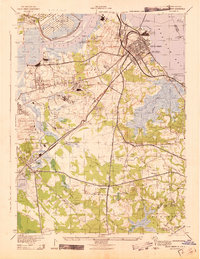
1943 Map of South Amboy
USGS Topo · Published 1943About this map
Industrial works and military sites dominate this coastal New Jersey landscape during the early 1940s. The northern shoreline along the Raritan River and Raritan Bay is a hub of heavy production, featuring the Nixon Nitration Works, Sayer & Fisher Brick Co, and the Federal Seaboard Terra Cotta Mfg Co. Inland, the Raritan Arsenal Military Reservation occupies a massive footprint north of the river, while the Pennsylvania Railroad and Raritan River Railroad create a dense network of transit for these industrial centers.
Find a feature on this map
75 named features on this map. Tap any name to fly to it.
Don’t see what you’re looking for? This feature index may not catch every label — zoom into the map to look around manually.
Map Details
Editions of this 1943 South Amboy Map
This is the sole edition of this map. No revisions or reprints were ever made.
Other maps of this area

1888 · Plainfield
USGS Topo · 1:62,500

1888 · New Brunswick
USGS Topo · 1:62,500

1888 · Sandy Hook
USGS Topo · 1:62,500

1893 · New Brunswick
USGS Topo · 1:62,500

1893 · Plainfield
USGS Topo · 1:62,500

1893 · Sandy Hook
USGS Topo · 1:62,500

1898 · Plainfield
USGS Topo · 1:62,500

1898 · Staten Island
USGS Topo · 1:62,500

1900 · Passaic
USGS Topo · 1:125,000

1900 · Staten Island
USGS Topo · 1:62,500