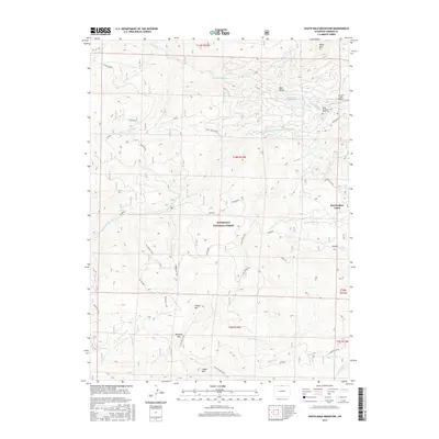
2016 Map of South Bald Mountain
USGS Topo · Published 2016About this map
Red Feather Lakes sits at the eastern edge of a high-altitude landscape defined by the watershed of the N Fork Cache La Poudre River. This 2016 survey illustrates the complex water management system of the region, featuring high-country infrastructure like the Panhandle Reservoir, Mitchell Ditch, and Bellaire Ditch alongside natural features such as Lake Erie. The terrain is dominated by a series of prominent peaks, including N Bald Mtn, Mid Bald Mtn, and S Bald Mtn, all within the boundaries of the Roosevelt National Forest. This area serves as a transition between the established lakeside community and the dense network of forest service roads and trails like Deadman and the Killpecker Trail. Local history is anchored by the Black Mountain Ranch Cem and the Crystal Lakes Airport, showing the intersection of ranching heritage and modern mountain living.
Find a feature on this map
46 named features on this map. Tap any name to fly to it.
Don’t see what you’re looking for? This feature index may not catch every label — zoom into the map to look around manually.
Map Details
Editions of this 2016 South Bald Mountain Map
This is the sole edition of this map. No revisions or reprints were ever made.
Other maps of this area

1916 · Home
USGS Topo · 1:125,000

1920 · Home
USGS Topo · 1:125,000

1954 · Greeley
USGS Topo · 1:250,000

1957 · Greeley
USGS Topo · 1:250,000

1958 · Greeley
USGS Topo · 1:250,000

1961 · Greeley
USGS Topo · 1:250,000

1962 · Boston Peak
USGS Topo · 1:24,000

1962 · Kinikinik
USGS Topo · 1:24,000
1962 · Rustic
USGS Topo · 1:24,000

1964 · Greeley
USGS Topo · 1:250,000