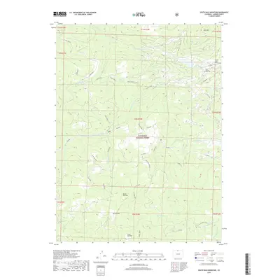
2019 Map of South Bald Mountain
USGS Topo · Published 2019About this map
Roosevelt National Forest dominates this high-altitude landscape, where several prominent peaks define the horizon. Significant elevation markers include North Bald Mtn, Mid Bald Mtn, and South Bald Mtn, which form a central ridge between the drainages of Killpecker Creek and North Lone Pine Creek. The northeastern corner transitions into a more developed area centered on Crystal Lakes, featuring the Crystal Lakes Airport and the Black Mountain Ranch Cemetery. This 2019 survey documents the complex water management systems of the region, specifically highlighting the Mitchell Ditch and Bellaire Ditch. These artificial waterways parallel natural courses like the North Fork Cache La Poudre River and Elkhorn Creek, illustrating how high-country runoff is channeled across the Divide. A network of named forest roads and trails, including Whiskeyman and Deadman, provides access through the densely wooded terrain.
Find a feature on this map
47 named features on this map. Tap any name to fly to it.
Don’t see what you’re looking for? This feature index may not catch every label — zoom into the map to look around manually.
Map Details
Editions of this 2019 South Bald Mountain Map
This is the sole edition of this map. No revisions or reprints were ever made.
Other maps of this area

1916 · Home
USGS Topo · 1:125,000

1920 · Home
USGS Topo · 1:125,000

1954 · Greeley
USGS Topo · 1:250,000

1957 · Greeley
USGS Topo · 1:250,000

1958 · Greeley
USGS Topo · 1:250,000

1961 · Greeley
USGS Topo · 1:250,000

1962 · Boston Peak
USGS Topo · 1:24,000

1962 · Kinikinik
USGS Topo · 1:24,000
1962 · Rustic
USGS Topo · 1:24,000

1964 · Greeley
USGS Topo · 1:250,000