
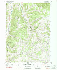
1954 Map of South Canisteo
USGS Topo · Published 1956About this map
Bennetts Creek and Colonel Bills Creek carve deep valleys through this part of the Southern Tier, defining a landscape where 1950s agriculture follows the narrow bottoms and lower slopes. The settlement pattern is dominated by small hamlets and rural crossroads such as South Canisteo and West Jasper, where the West Jasper Ch serves as a community anchor. Higher elevations are marked by significant peaks like Bush Hill and Old Baldy, while the western edge reveals the State Reforestation Area, reflecting early mid-century land conservation efforts. For genealogists, the map is particularly rich with family-named landmarks and burial grounds, including the Carter Cem, Thomas Cem, and the elevated Marsh Hill Cem. Numerous hollows like Spaulding Hollow and Norton Hollow indicate the rugged drainage patterns that influenced early road placement and property lines.
Find a feature on this map
38 named features on this map. Tap any name to fly to it.
Don’t see what you’re looking for? This feature index may not catch every label — zoom into the map to look around manually.
Map Details
Editions of this 1954 South Canisteo Map
2 editions found
Other maps of this area

1910 · Bath
USGS Topo · 1:62,500

1915 · Hornell
USGS Topo · 1:62,500

1918 · Hornell
USGS Topo · 1:62,500

1924 · Woodhull
USGS Topo · 1:48,000

1926 · Woodhull
USGS Topo · 1:62,500

1926 · Greenwood
USGS Topo · 1:62,500

1944 · Woodhull
USGS Topo · 1:62,500

1950 · Elmira
USGS Topo · 1:250,000

1953 · Cameron
USGS Topo · 1:24,000

1953 · Woodhull
USGS Topo · 1:24,000