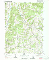
1954 Map of South Canisteo
USGS Topo · Published 1988About this map
South Canisteo and the surrounding rural uplands of Steuben County appear here as they were mid-century, defined by a network of narrow valleys and high ridges. The landscape is deeply carved by drainage systems like Bennett Creek and Colonel Bills Creek, which dictated the placement of small settlements and family farms. At the intersection of local routes, small communities such as Bennetts, Hampshire, and Dennis Corners served as local hubs. The southern portion of the map includes a significant State Reforestation Area, indicating a shift in land use on the steeper slopes of Greenwood Hill and Jackson ridge. Genealogists will find several burial grounds noted, including Thomas Cem and the Hampshire Cem near the town of Jasper, along with the West Jasper Ch, providing a detailed look at the social and religious infrastructure of this farming region.
Find a feature on this map
45 named features on this map. Tap any name to fly to it.
Don’t see what you’re looking for? This feature index may not catch every label — zoom into the map to look around manually.
Map Details
Editions of this 1954 South Canisteo Map
2 editions found

Other maps of this area

1910 · Bath
USGS Topo · 1:62,500

1915 · Hornell
USGS Topo · 1:62,500

1918 · Hornell
USGS Topo · 1:62,500

1924 · Woodhull
USGS Topo · 1:48,000

1926 · Woodhull
USGS Topo · 1:62,500

1926 · Greenwood
USGS Topo · 1:62,500

1944 · Woodhull
USGS Topo · 1:62,500

1950 · Elmira
USGS Topo · 1:250,000

1953 · Cameron
USGS Topo · 1:24,000

1953 · Woodhull
USGS Topo · 1:24,000