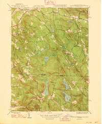
1948 Map of South Sandisfield
USGS Topo · Published 1948About this map
The borderlands of Berkshire and Litchfield counties appear here as a landscape of dense woodlands and high ridges, defined by the winding course of Sandy Brook and the high peaks of Woodruff Mountain and Haystack Mountain. This mid-century survey documents the transition from small rural hamlets like South Sandisfield and Southfield to the preservation of land within the Sandisfield State Forest. Evidence of earlier settlement is visible in the numerous burial grounds, such as Montville Cem and Huxley Cem, while the emerging recreational character of the area is seen at the YMCA Camp on Harmon Pond.
Find a feature on this map
98 named features on this map. Tap any name to fly to it.
Don’t see what you’re looking for? This feature index may not catch every label — zoom into the map to look around manually.
Map Details
Editions of this 1948 South Sandisfield Map
2 editions found
Other maps of this area

1885 · Sheffield
USGS Topo · 1:62,500

1888 · Sheffield
USGS Topo · 1:62,500

1888 · Sandisfield
USGS Topo · 1:62,500

1891 · Sheffield
USGS Topo · 1:62,500

1892 · Winsted
USGS Topo · 1:62,500

1892 · Cornwall
USGS Topo · 1:62,500

1893 · Sheffield
USGS Topo · 1:62,500

1893 · Cornwall
USGS Topo · 1:62,500

1893 · Sandisfield
USGS Topo · 1:62,500

1897 · Sandisfield
USGS Topo · 1:62,500