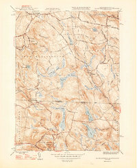
1948 Map of South Sandisfield
USGS Topo · Published 1948About this map
Sandy Brook and the Umpachene River carve through the highland terrain of the Massachusetts-Connecticut border, anchoring a landscape defined by small mid-century village centers and timbered tracts. The area is divided between the towns of New Marlborough and Sandisfield, where local life centered around points like Southfield and Montville. The map captures a transition in land use, from the scattered upland farms marked by the Palmer Cem and Huxley Cem to the emerging recreational footprints of Sandisfield State Forest and the YMCA Camp.
Find a feature on this map
61 named features on this map. Tap any name to fly to it.
Don’t see what you’re looking for? This feature index may not catch every label — zoom into the map to look around manually.
Map Details
Editions of this 1948 South Sandisfield Map
2 editions found
Other maps of this area

1885 · Sheffield
USGS Topo · 1:62,500

1888 · Sheffield
USGS Topo · 1:62,500

1888 · Sandisfield
USGS Topo · 1:62,500

1891 · Sheffield
USGS Topo · 1:62,500

1892 · Winsted
USGS Topo · 1:62,500

1892 · Cornwall
USGS Topo · 1:62,500

1893 · Sheffield
USGS Topo · 1:62,500

1893 · Cornwall
USGS Topo · 1:62,500

1893 · Sandisfield
USGS Topo · 1:62,500

1897 · Sandisfield
USGS Topo · 1:62,500