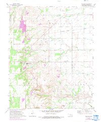
1972 Map of Southard
USGS Topo · Published 1983About this map
Quarries dominate this landscape in Blaine County, revealing the intensive industrial operations centered around Southard. The 1972 data, revised with 1981 aerial updates, tracks the extensive surface mining and industrial footprint required for gypsum processing, including the Ruby Mill and a local Substation. The Burlington Northern railroad serves as the primary artery for these operations, connecting the industrial hub at Southard with the smaller settlement at Darrow to the east.
Find a feature on this map
24 named features on this map. Tap any name to fly to it.
Don’t see what you’re looking for? This feature index may not catch every label — zoom into the map to look around manually.
Map Details
Editions of this 1972 Southard Map
2 editions found
Other maps of this area

1955 · Clinton
USGS Topo · 1:250,000

1955 · Woodward
USGS Topo · 1:250,000

1957 · Clinton
USGS Topo · 1:250,000

1958 · Woodward
USGS Topo · 1:250,000

1964 · Oakwood
USGS Topo · 1:62,500

1972 · Longdale
USGS Topo · 1:24,000

1972 · Canton
USGS Topo · 1:24,000

1972 · Southard
USGS Topo · 1:24,000

1972 · Okeene
USGS Topo · 1:24,000

1972 · Homestead
USGS Topo · 1:24,000