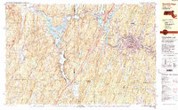
1982 Map of Southbridge
USGS Topo · Published 1983About this map
The Quinebaug River valley serves as the industrial and social backbone of this early 1980s landscape, connecting the core of Southbridge with outlying villages like Sandersdale and Westville. This era shows a community defined by its topography and water resources, with numerous reservoirs and ponds such as Hamilton Reservoir and East Brimfield Lake managing the flow through the narrow valleys. The map documents a dense network of local landmarks, including the Southbridge Municipal Airport and multiple Catholic cemeteries like St Marys Cem and Notre Dame Cem, reflecting the town's cultural heritage.
Find a feature on this map
66 named features on this map. Tap any name to fly to it.
Don’t see what you’re looking for? This feature index may not catch every label — zoom into the map to look around manually.
Map Details
Editions of this 1982 Southbridge Map
2 editions found
Other maps of this area

1887 · Brookfield
USGS Topo · 1:62,500

1887 · Palmer
USGS Topo · 1:62,500

1889 · Webster
USGS Topo · 1:62,500

1889 · Putnam
USGS Topo · 1:62,500

1889 · Palmer
USGS Topo · 1:62,500

1890 · Brookfield
USGS Topo · 1:62,500

1892 · Woodstock
USGS Topo · 1:62,500

1892 · Webster
USGS Topo · 1:62,500

1892 · Tolland
USGS Topo · 1:62,500

1893 · Putnam
USGS Topo · 1:62,500