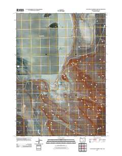
2011 Map of Southeast Harney Lake
USGS Topo · Published 2011About this map
Harney Lake dominates the upper-left landscape of this high-desert region in Harney County, illustrating the expansive, seasonal nature of Oregon's alkaline basins. The hydrology of this arid environment is further defined by the intermittent flow of Jackass Creek and the isolated presence of Bathtub Spring. These water sources were historically vital for local rangeland operations and the movement of livestock. Grounded in the early 21st century, the map details the infrastructure connecting this remote basin, specifically S Harney Rd and Catlow Rd. Between these arterial routes, the terrain transitions through the Sand Gap into the level expanse of Weed Lake Flat, highlighting the subtle topographic shifts that define the southeastern shores of the lake basin.
Find a feature on this map
7 named features on this map. Tap any name to fly to it.
Don’t see what you’re looking for? This feature index may not catch every label — zoom into the map to look around manually.
Map Details
Editions of this 2011 Southeast Harney Lake Map
This is the sole edition of this map. No revisions or reprints were ever made.
Other maps of this area

1955 · Burns
USGS Topo · 1:250,000

1958 · Burns
USGS Topo · 1:250,000

1959 · Burns
USGS Topo · 1:250,000

1959 · Dog Mountain
USGS Topo · 1:62,500

1959 · Lawen
USGS Topo · 1:62,500

1967 · Coyote Buttes
USGS Topo · 1:24,000

1967 · Jackass Butte
USGS Topo · 1:24,000

1978 · Malheur Lake
USGS Topo · 1:100,000
1980 · Twin Buttes
USGS Topo · 1:24,000
1980 · Jackass Butte
USGS Topo · 1:24,000