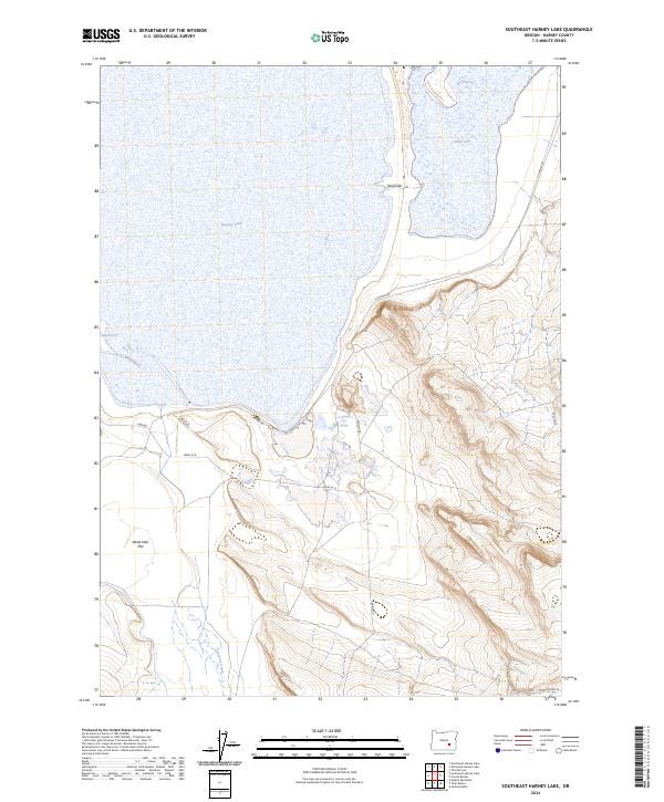
2024 Map of Southeast Harney Lake
USGS Topo · Published 2024About this map
Malheur National Wildlife Refuge encompasses the central portion of this High Desert landscape, where the seasonal waters of Harney Lake and Mud Lake meet a terrain shaped by volcanic and geothermal activity. The hydrology of the basin is marked by several thermal features and seeps, most notably Pronghorn Hot Springs near the shore of the main lake, along with Lynch Spring and Barnhardi Spring. This area is characterized by vast alkali flats and seasonal wetlands, with Weed Lake Flat extending across the southern reaches.
Find a feature on this map
19 named features on this map. Tap any name to fly to it.
Don’t see what you’re looking for? This feature index may not catch every label — zoom into the map to look around manually.
Map Details
Editions of this 2024 Southeast Harney Lake Map
This is the sole edition of this map. No revisions or reprints were ever made.
Other maps of this area

1955 · Burns
USGS Topo · 1:250,000

1958 · Burns
USGS Topo · 1:250,000

1959 · Burns
USGS Topo · 1:250,000

1959 · Dog Mountain
USGS Topo · 1:62,500

1959 · Lawen
USGS Topo · 1:62,500

1967 · Coyote Buttes
USGS Topo · 1:24,000

1967 · Jackass Butte
USGS Topo · 1:24,000

1978 · Malheur Lake
USGS Topo · 1:100,000
1980 · Twin Buttes
USGS Topo · 1:24,000
1980 · Jackass Butte
USGS Topo · 1:24,000