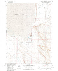
1980 Map of Southeast Harney Lake
USGS Topo · Published 1980About this map
The Malheur National Wildlife Refuge dominates this desert basin, illustrating the complex hydrology of the high desert during the 1970s. The landscape is defined by the expansive, often dry beds of Harney Lake and Weed Lake Flat, where geothermal activity is evident in named features like Bathtub Spring (Hot) and other Springs (Hot). This survey captures the transition from the shifting Sand Dunes in the north to the low-lying Alkali Flat, a region where water is a scarce and precious resource, marked by scattered water sources such as Lynch Spring and the drainage of Jackass Creek. Small-scale exploration is noted in the hills near the eastern boundary, where Prospects suggest historical interest in the area's geology.
Find a feature on this map
18 named features on this map. Tap any name to fly to it.
Don’t see what you’re looking for? This feature index may not catch every label — zoom into the map to look around manually.
Map Details
Editions of this 1980 Southeast Harney Lake Map
This is the sole edition of this map. No revisions or reprints were ever made.
Other maps of this area

1955 · Burns
USGS Topo · 1:250,000

1958 · Burns
USGS Topo · 1:250,000

1959 · Burns
USGS Topo · 1:250,000

1959 · Dog Mountain
USGS Topo · 1:62,500

1959 · Lawen
USGS Topo · 1:62,500

1967 · Coyote Buttes
USGS Topo · 1:24,000

1967 · Jackass Butte
USGS Topo · 1:24,000

1978 · Malheur Lake
USGS Topo · 1:100,000
1980 · Twin Buttes
USGS Topo · 1:24,000
1980 · Jackass Butte
USGS Topo · 1:24,000