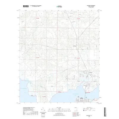
2018 Map of Southport
USGS Topo · Published 2018About this map
North Bay and the extensive inlet system of West Bay dominate this coastal landscape, where the land breaks into a complex series of fingers and peninsulas. The community of Southport sits at a critical junction near Fannin Bayou, while to the north, the small settlement of Vicksburg is situated along the corridor of Co Rd 388. The geography is defined by its maritime interface, with numerous named waterways such as Alligator Bayou, Newman Bayou, and Sheephead Bayou cutting deep into the piney flatwoods. Along the southern edge, the northern reaches of Lynn Haven appear near Haven Point and Mill Point, marking the transition toward more developed residential areas. This map documents a region where low-lying wetlands and hammocks like Cedar Hammock are increasingly intersected by modern road networks including Hwy 2300 and Skunk Valley Rd.
Find a feature on this map
91 named features on this map. Tap any name to fly to it.
Don’t see what you’re looking for? This feature index may not catch every label — zoom into the map to look around manually.
Map Details
Editions of this 2018 Southport Map
This is the sole edition of this map. No revisions or reprints were ever made.
Other maps of this area

1943 · Panama City
USGS Topo · 1:31,680

1943 · Panama City Beach
USGS Topo · 1:31,680

1943 · West Bay
USGS Topo · 1:24,000

1943 · Southport
USGS Topo · 1:24,000

1944 · Southport
USGS Topo · 1:24,000

1944 · West Bay
USGS Topo · 1:31,680

1944 · Crystal Lake
USGS Topo · 1:24,000

1944 · Bayhead
USGS Topo · 1:24,000

1944 · Bennett
USGS Topo · 1:24,000

1945 · Bennett
USGS Topo · 1:31,680