1980 Map of Southport
USGS Topo · Published 1985About this map
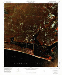
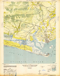
Fort Caswell anchors the tip of Oak Island in this infrared orthophoto, marking the strategic entrance where the Elizabeth River meets the Cape Fear River. The coastal landscape of the early 1980s reveals the established beachfront communities of Long Beach, Yaupon Beach, and Caswell Beach, showing the residential street grids as they appeared before decades of further shoreline development.
Find a feature on this map
17 named features on this map. Tap any name to fly to it.
Don’t see what you’re looking for? This feature index may not catch every label — zoom into the map to look around manually.
Map Details
Editions of this 1980 Southport Map
This is the sole edition of this map. No revisions or reprints were ever made.
Other maps of this area

1942 · Wilmington
USGS Topo · 1:62,500

1942 · Cape Fear
USGS Topo · 1:24,000
1943 · Funston
USGS Topo · 1:24,000
1943 · Bolivia
USGS Topo · 1:24,000

1943 · Lockwoods Folly
USGS Topo · 1:24,000
1944 · Bolivia
USGS Topo · 1:31,680

1944 · Lockwoods Folly
USGS Topo · 1:31,680
1946 · Southport
USGS Topo · 1:24,000

1946 · Snow Marsh
USGS Topo · 1:24,000

1948 · Wilmington
USGS Topo · 1:62,500