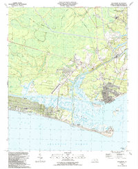
1990 Map of Southport
USGS Topo · Published 1991About this map
Southport stands as the historic anchor of this Brunswick County coastline, where the Cape Fear River meets the Atlantic Ocean. By the late 1980s, the area reflects a complex layering of maritime defense and growing coastal communities. The southern edge is defined by the expansive barrier island developments of Long Beach, Yaupon Beach, and Caswell Beach, while the legendary Fort Caswell guards the entrance to the river. Inland, the landscape is a network of marshes and creeks like Dutchman Creek and Jump and Run Creek, punctuated by small settlements and rural landmarks.
Find a feature on this map
51 named features on this map. Tap any name to fly to it.
Don’t see what you’re looking for? This feature index may not catch every label — zoom into the map to look around manually.
Map Details
Editions of this 1990 Southport Map
This is the sole edition of this map. No revisions or reprints were ever made.
Other maps of this area

1942 · Wilmington
USGS Topo · 1:62,500

1942 · Cape Fear
USGS Topo · 1:24,000

1943 · Funston
USGS Topo · 1:24,000

1943 · Bolivia
USGS Topo · 1:24,000

1943 · Lockwoods Folly
USGS Topo · 1:24,000

1944 · Bolivia
USGS Topo · 1:31,680

1944 · Lockwoods Folly
USGS Topo · 1:31,680

1946 · Southport
USGS Topo · 1:24,000

1946 · Snow Marsh
USGS Topo · 1:24,000

1948 · Wilmington
USGS Topo · 1:62,500