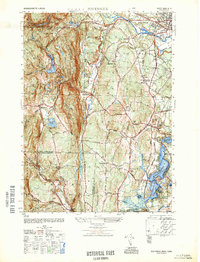
1948 Map of Southwick
USGS Topo · Published 1948About this map
Congamond Lakes anchor the southeastern corner of this study, marking a distinctive watery boundary between Massachusetts and Connecticut. The 1948 landscape reveals a post-war rural character where agricultural land meets the developing recreational and infrastructure needs of Westfield. The presence of the West Parish Filters and multiple reservoirs, including Granville Reservoir and Westfield Reservoir, underscores the region's importance as a watershed for nearby urban centers.
Find a feature on this map
68 named features on this map. Tap any name to fly to it.
Don’t see what you’re looking for? This feature index may not catch every label — zoom into the map to look around manually.
Map Details
Editions of this 1948 Southwick Map
This is the sole edition of this map. No revisions or reprints were ever made.
Other maps of this area

1886 · Springfield
USGS Topo · 1:62,500

1887 · Granville
USGS Topo · 1:62,500

1889 · Springfield
USGS Topo · 1:62,500

1889 · Granville
USGS Topo · 1:62,500

1892 · Hartford
USGS Topo · 1:62,500

1892 · Granby
USGS Topo · 1:62,500

1893 · Springfield
USGS Topo · 1:62,500

1893 · Granville
USGS Topo · 1:62,500

1895 · Springfield
USGS Topo · 1:62,500

1895 · Granville
USGS Topo · 1:62,500