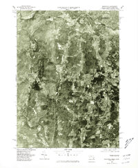
1976 Map of Southwick
USGS Topo · Published 1981About this map
Southwick and the surrounding borderlands of Massachusetts and Connecticut appear in this mid-1970s orthophoto survey, which utilizes aerial imagery from 1976. The landscape is a complex patchwork of forest and agricultural fields, with the Congamond Lakes anchoring the southeastern corner. This photographic perspective provides a unique look at the rural development patterns of the era, from the established streets of Westfield in the northeast to the smaller clusters at Gillett Corner and Mundale. The winding course of the Little River cuts through the northern terrain, while the western edge reaches toward the community of Granville. This edition is particularly valuable for documenting the specific locations of homesteads, woodlots, and field boundaries before later suburban expansion altered the local geography near the village of Congamond.
Find a feature on this map
8 named features on this map. Tap any name to fly to it.
Don’t see what you’re looking for? This feature index may not catch every label — zoom into the map to look around manually.
Map Details
Editions of this 1976 Southwick Map
This is the sole edition of this map. No revisions or reprints were ever made.
Other maps of this area

1886 · Springfield
USGS Topo · 1:62,500

1887 · Granville
USGS Topo · 1:62,500

1889 · Springfield
USGS Topo · 1:62,500

1889 · Granville
USGS Topo · 1:62,500

1892 · Hartford
USGS Topo · 1:62,500

1892 · Granby
USGS Topo · 1:62,500

1893 · Springfield
USGS Topo · 1:62,500

1893 · Granville
USGS Topo · 1:62,500

1895 · Springfield
USGS Topo · 1:62,500

1895 · Granville
USGS Topo · 1:62,500