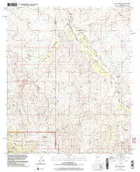
1996 Map of Soza Canyon
USGS Topo · Published 2003About this map
The San Pedro River valley carves through the center of this landscape, flanked by the high elevations of the Coronado National Forest and the Rincon Mountain Wilderness. This 1996 survey records a transition from river-bottom ranching at Spear Ranch and Bar LY Ranch to the more isolated mining prospects of the western ridges. Along the eastern banks, the settlement of Cascabel serves as a focal point for the rural corridor, preserving the legacy of earlier habitation at the Cascabel School (Site) and the Gibson Ranch (Site). The terrain is defined by dramatic erosional features like Soza Canyon and Banco Ridge, where scattered wells and vital water sources such as Roble Spring and Espiritu Spring supported livestock and homesteads in a desert environment where the presence of Landing Strips indicates the necessity of aerial access for these remote holdings.
Find a feature on this map
41 named features on this map. Tap any name to fly to it.
Don’t see what you’re looking for? This feature index may not catch every label — zoom into the map to look around manually.
Map Details
Editions of this 1996 Soza Canyon Map
This is the sole edition of this map. No revisions or reprints were ever made.
Other maps of this area

1904 · Tucson
USGS Topo · 1:125,000

1905 · Tucson
USGS Topo · 1:125,000

1945 · Redington
USGS Topo · 1:62,500

1945 · Happy Valley
USGS Topo · 1:62,500

1956 · Tucson
USGS Topo · 1:250,000

1957 · Bellota Ranch
USGS Topo · 1:62,500

1957 · Rincon Valley
USGS Topo · 1:62,500

1957 · Redington
USGS Topo · 1:62,500

1958 · Tucson
USGS Topo · 1:250,000

1958 · Happy Valley
USGS Topo · 1:62,500