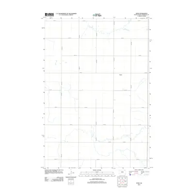
2012 Map of Spain
USGS Topo · Published 2012About this map
The settlement of Spain occupies a central position within this portion of Marshall County, situated along a structured grid of rural roads and section lines. The landscape is defined by the winding course of Crow Cr as it meanders through the northern sections, providing a natural contrast to the geometric precision of the surrounding infrastructure. This 2012 survey documents a sparsely populated agricultural region where the primary organization is dictated by the intersection of long-distance routes like 421st Ave and 113th St. The map captures the quiet character of the South Dakota prairie, emphasizing the spatial relationship between the small community center and the watercourses that drain the surrounding fields. For those tracing the evolution of local townships, the map preserves the exact alignment of historical section roads and the drainage patterns of the local creek system.
Find a feature on this map
16 named features on this map. Tap any name to fly to it.
Don’t see what you’re looking for? This feature index may not catch every label — zoom into the map to look around manually.
Map Details
Editions of this 2012 Spain Map
This is the sole edition of this map. No revisions or reprints were ever made.
Other maps of this area

1953 · Britton East
USGS Topo · 1:24,000

1953 · Newark SW
USGS Topo · 1:24,000

1953 · Milbank
USGS Topo · 1:250,000

1956 · Britton West
USGS Topo · 1:24,000

1958 · Milbank
USGS Topo · 1:250,000

1958 · Spain
USGS Topo · 1:24,000

1958 · Britton 4 NW
USGS Topo · 1:24,000

1958 · Britton 4 SW
USGS Topo · 1:24,000
1958 · Amherst
USGS Topo · 1:24,000

1958 · Langford
USGS Topo · 1:24,000