
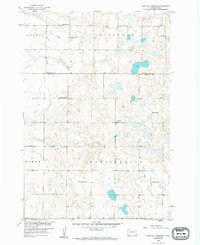
1958 Map of Britton 4 SW
USGS Topo · Published 1959About this map
The glaciated plains of the Marshall and Day County border are defined by a complex network of wetlands and prairie potholes in this late-1950s survey. This landscape was mapped as part of a Department of the Interior program for the development of the Missouri River Basin, revealing a rural community structured around the township sections of Hickman, Sisseton, Homer, Independence, and Lynn. The map provides a detailed look at the infrastructure of the time, where local education was still decentralized across numerous numbered schoolhouses, such as School No 3 and School No 226. Religious and communal life centers on Highlands Ch and Falnes Ch, while the presence of the Jandahl Sch and family-named burial grounds like Hanson Cem offer clear evidence of the area's established homesteading history.
Find a feature on this map
18 named features on this map. Tap any name to fly to it.
Don’t see what you’re looking for? This feature index may not catch every label — zoom into the map to look around manually.
Map Details
Editions of this 1958 Britton 4 SW Map
2 editions found
Other maps of this area

1953 · Milbank
USGS Topo · 1:250,000

1958 · Milbank
USGS Topo · 1:250,000

1958 · Spain
USGS Topo · 1:24,000

1958 · Britton 4 NW
USGS Topo · 1:24,000

1958 · Langford
USGS Topo · 1:24,000

1958 · Pierpont
USGS Topo · 1:24,000

1970 · Britton 4 NE
USGS Topo · 1:24,000

1970 · Britton 4 SE
USGS Topo · 1:24,000

1973 · Lynn Lake
USGS Topo · 1:24,000
1973 · Webster NE
USGS Topo · 1:24,000