
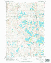
1970 Map of Britton 4 NE
USGS Topo · Published 1973About this map
Fort Sisseton State Park serves as a centerpiece of this Marshall County landscape, where the Old Sisseton Military Reservation Boundary still marks the historical division of the land. The area is defined by a dense concentration of glacial lakes and sloughs, including the numerically named Twomile Lake, Threemile Lake, and Fourmile Lake. These water bodies, along with Lee Lake and Hawkeye Lake, suggest a terrain shaped by receding ice, creating a complex patchwork of water and land that dictated early settlement patterns.
Find a feature on this map
22 named features on this map. Tap any name to fly to it.
Don’t see what you’re looking for? This feature index may not catch every label — zoom into the map to look around manually.
Map Details
Editions of this 1970 Britton 4 NE Map
2 editions found
Other maps of this area

1953 · Britton East
USGS Topo · 1:24,000

1953 · Milbank
USGS Topo · 1:250,000

1954 · Kidder SE
USGS Topo · 1:24,000

1958 · Milbank
USGS Topo · 1:250,000

1958 · Britton 4 NW
USGS Topo · 1:24,000

1958 · Hillhead
USGS Topo · 1:24,000

1958 · Britton 4 SW
USGS Topo · 1:24,000

1970 · Eden
USGS Topo · 1:24,000

1970 · Lake City
USGS Topo · 1:24,000

1970 · Britton 4 SE
USGS Topo · 1:24,000