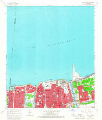
1965 Map of Spanish Fort
USGS Topo · Published 1966About this map
Lake Pontchartrain defines the northern reaches of this mid-century New Orleans survey, showing the city's complex relationship with its waterfront. The shoreline is densely packed with recreational and institutional sites, from the historic Spanish Fort Ruins near Bayou St John to the modern sprawl of the New Orleans Lakefront Airport and Pontchartrain Beach. The map highlights a significant military and educational presence in the Gentilly area, including Camp Leroy Johnson, the U S Naval Reserve Headquarters, and the Southern University (New Orleans Branch). Interior neighborhoods like Lakeshore Park and Lake Vista Park appear fully developed, gridded by iconic thoroughfares such as Elysian Fields Ave and Lakeshore Dr. To the east, the Inner Harbor Navigation Canal and the G M & O RR tracks signal the industrial and transit arteries supporting the city's growth during this era.
Find a feature on this map
107 named features on this map. Tap any name to fly to it.
Don’t see what you’re looking for? This feature index may not catch every label — zoom into the map to look around manually.
Map Details
Editions of this 1965 Spanish Fort Map
4 editions found
Other maps of this area

1891 · Spanish Fort
USGS Topo · 1:62,500

1891 · New Orleans
USGS Topo · 1:62,500

1892 · Chef Menteur
USGS Topo · 1:62,500

1892 · St. Bernard
USGS Topo · 1:62,500

1932 · New Orleans NE
USGS Topo · 1:31,680

1932 · New Orleans NW
USGS Topo · 1:31,680

1936 · South Point
USGS Topo · 1:31,680

1936 · Chef Menteur
USGS Topo · 1:62,500

1936 · Spanish Fort
USGS Topo · 1:62,500

1938 · Little Woods
USGS Topo · 1:31,680