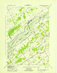
1943 Map of Sparrowhawk Point
USGS Topo · Published 1943About this map
St Lawrence River serves as the international boundary on this mid-century survey, dividing New York from Ontario. Along the northern bank, the Galop Canal and the Canadian National railroad parallel the shore through the village of Iroquois. On the American side, the landscape is defined by its rural infrastructure, featuring a high density of local schoolhouses and country churches. Family legacy is preserved in locations like Livingston Cem and Brown Ch, while the agricultural character of the towns of Madrid and Lisbon is etched into the grid of Dezell Road and Middle Road. The map also captures the river's complex archipelago before major seaway developments, documenting Toussaint Island, Lotus Island, and Lalone Island in their pre-modern configuration.
Find a feature on this map
39 named features on this map. Tap any name to fly to it.
Don’t see what you’re looking for? This feature index may not catch every label — zoom into the map to look around manually.
Map Details
Editions of this 1943 Sparrowhawk Point Map
This is the sole edition of this map. No revisions or reprints were ever made.
Other maps of this area

1904 · Lisbon
USGS Topo · 1:48,000

1904 · Ogdensburg
USGS Topo · 1:62,500

1905 · Waddington
USGS Topo · 1:62,500

1905 · Ogdensburg
USGS Topo · 1:62,500

1906 · Red Mills
USGS Topo · 1:62,500

1910 · Canton
USGS Topo · 1:62,500

1911 · Canton
USGS Topo · 1:62,500

1942 · Waddington
USGS Topo · 1:24,000

1942 · Murphy Island
USGS Topo · 1:24,000

1943 · Ogdensburg East
USGS Topo · 1:31,680