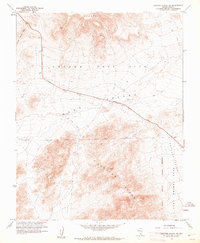
1961 Map of Specter Range NW
USGS Topo · Published 1962About this map
The Nevada Test Site dominates this early 1960s topographic study, reflecting the Atomic Energy Commission's intensive activity in the Nye County desert. The landscape is defined by the high elevations of the Specter Range and Skull Mountain, with the low-lying Rock Valley and Mercury Valley serving as corridors for military and research operations. Transport and communication infrastructure, crucial for the site's mission, are evident through the Jackass Flats Road and a remote Radio Facility perched at a high elevation. This map documents a period when the Camp Desert Rock Military Reservation was a focal point for personnel and logistics. Localized industrial traces like a Gravel Pit and Sandpit illustrate the ongoing construction and support needs within this secure government zone.
Find a feature on this map
15 named features on this map. Tap any name to fly to it.
Don’t see what you’re looking for? This feature index may not catch every label — zoom into the map to look around manually.
Map Details
Editions of this 1961 Specter Range NW Map
2 editions found
Other maps of this area

1908 · Furnace Creek
USGS Topo · 1:250,000

1910 · Furnace Creek
USGS Topo · 1:250,000

1942 · Skull Mountain
USGS Topo · 1:125,000

1948 · Death Valley
USGS Topo · 1:250,000

1952 · Topopah Spring
USGS Topo · 1:62,500

1952 · Specter Range
USGS Topo · 1:62,500
1952 · Cane Spring
USGS Topo · 1:62,500

1954 · Death Valley
USGS Topo · 1:250,000

1956 · Death Valley
USGS Topo · 1:250,000

1957 · Death Valley
USGS Topo · 1:250,000