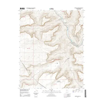
2014 Map of Spencer Canyon
USGS Topo · Published 2014About this map
The Colorado River cuts through the northeast corner of this Mohave County landscape, marked by treacherous water features including Lost Creek Rapids, Surprise Rapid, and Lava Rapids. This 2014 survey documents the convergence of two major federal protected areas, with Grand Canyon National Park meeting the Lake Mead National Recreation Area along the river's edge. To the south and west, the terrain rises toward the Sanup Plateau, revealing a complex system of drainages such as Clay Tank Canyon, Surprise Canyon, and Meriwhitica Canyon. Permanent water sources like Meriwhitica Springs, Spencer Springs, and White Spring are vital landmarks in this arid environment. The map also identifies Indian Gardens, a site tucked into the canyon depths, providing essential context for the hydrological and topographic character of the region during the early 21st century.
Find a feature on this map
25 named features on this map. Tap any name to fly to it.
Don’t see what you’re looking for? This feature index may not catch every label — zoom into the map to look around manually.
Map Details
Editions of this 2014 Spencer Canyon Map
This is the sole edition of this map. No revisions or reprints were ever made.
Other maps of this area

1886 · Diamond Creek
USGS Topo · 1:250,000

1892 · Diamond Creek
USGS Topo · 1:250,000

1948 · Williams
USGS Topo · 1:250,000

1954 · Williams
USGS Topo · 1:250,000

1956 · Williams
USGS Topo · 1:250,000

1960 · Williams
USGS Topo · 1:250,000

1961 · Williams
USGS Topo · 1:250,000
1967 · Milkweed Canyon NW
USGS Topo · 1:24,000
1967 · Separation Canyon
USGS Topo · 1:24,000
1967 · Devils Slide Rapids
USGS Topo · 1:24,000