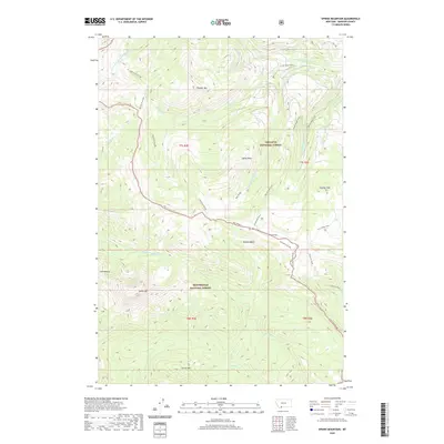
2020 Map of Sphinx Mountain
USGS Topo · Published 2020About this map
Sphinx Mtn and The Helmet dominate this high-elevation landscape within the Beaverhead National Forest and Gallatin National Forest. This 2020 survey details a complex network of ridgelines and water sources, most notably the Inspiration Divide which snakes through the central terrain. The map documents the high-country hydrology of the Madison Range, including the headwaters of McAtee Cr, Indian Cr, and the S Fork W Fork Gallatin River. Significant landmarks like Yellowmule Cabin and Eglise Rock are situated among the peaks, while named drainage features such as McAtee Basin and Buck Ridge illustrate the area's geological character. This modern topographic record captures the established trail systems and forest boundaries that define this part of Madison County, providing a precise look at the drainage patterns of Pioneer Mountain and Circle Mtn.
Find a feature on this map
34 named features on this map. Tap any name to fly to it.
Don’t see what you’re looking for? This feature index may not catch every label — zoom into the map to look around manually.
Map Details
Editions of this 2020 Sphinx Mountain Map
This is the sole edition of this map. No revisions or reprints were ever made.
Other maps of this area

1888 · Three Forks
USGS Topo · 1:250,000

1894 · Three Forks
USGS Topo · 1:250,000

1895 · Three Forks
USGS Topo · 1:250,000

1947 · Bozeman
USGS Topo · 1:250,000

1948 · Bozeman
USGS Topo · 1:250,000

1949 · Ennis
USGS Topo · 1:62,500

1950 · Cameron
USGS Topo · 1:62,500

1950 · Spanish Peaks
USGS Topo · 1:62,500

1950 · Sphinx Mountain
USGS Topo · 1:62,500

1955 · Bozeman
USGS Topo · 1:250,000