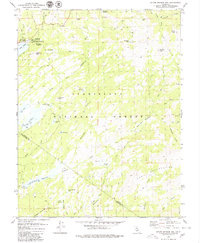
1979 Map of Spicer Meadow Res.
USGS Topo · Published 1980About this map
The Stanislaus National Forest landscape shown here in the late 1970s is defined by a series of significant water storage projects along the Alpine and Tuolumne county line. The high Sierra terrain is dominated by the expansive Spicer Meadow Reservoir and Union Reservoir, both essential components of the region's hydro-management. Outdoor recreation and seasonal settlement are central to the area's character, evidenced by the cluster of facilities at Lake Alpine, including the Silver Valley Campground and Pine Marten Campground. The map traces a complex network of pack trails navigating the granite peaks and high meadows, connecting landmarks like Elephant Rock and Bull Run Peak. The inclusion of the Emigrant Wilderness boundary and the Gaging Station reflects the dual nature of this land as both a protected wilderness and a managed resource for the North Fork Stanislaus River watershed.
Find a feature on this map
50 named features on this map. Tap any name to fly to it.
Don’t see what you’re looking for? This feature index may not catch every label — zoom into the map to look around manually.
Map Details
Editions of this 1979 Spicer Meadow Res. Map
3 editions found
Other maps of this area

1889 · Pyramid Peak
USGS Topo · 1:125,000

1889 · Markleeville
USGS Topo · 1:125,000

1891 · Markleeville
USGS Topo · 1:125,000

1891 · Big Trees
USGS Topo · 1:125,000

1891 · Pyramid Peak
USGS Topo · 1:125,000

1893 · Markleeville
USGS Topo · 1:125,000

1894 · Big Trees
USGS Topo · 1:125,000

1895 · Pyramid Peak
USGS Topo · 1:125,000

1896 · Dardanelles
USGS Topo · 1:125,000

1896 · Pyramid Peak
USGS Topo · 1:125,000