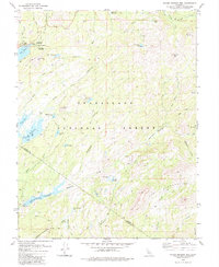
1979 Map of Spicer Meadow Res
USGS Topo · Published 1984About this map
The North Fork Stanislaus River drainage serves as the primary artery for this high-elevation landscape, where numerous lakes and reservoirs mark the granite-rich terrain of the Stanislaus National Forest. In the late 1970s, the area's geography was defined by significant water management infrastructure, including the Spicer Meadow Reservoir, Union Reservoir, and Utica Res. The presence of several established recreational sites like Pine Marten Campground and Silver Valley Campground near Lake Alpine reflects the region's importance for wilderness access. Landowners and genealogists may note specific named locations like McCauley and McCormick or family-identified landmarks such as Whittakers Dardanelles Spring. Dramatic geological features, most notably The Dardanelles and the massif of Elephant Rock, dominate the southern and central sections, while the Emigrant Wilderness boundary separates more developed recreational zones from the protected backcountry.
Find a feature on this map
58 named features on this map. Tap any name to fly to it.
Don’t see what you’re looking for? This feature index may not catch every label — zoom into the map to look around manually.
Map Details
Editions of this 1979 Spicer Meadow Res Map
3 editions found
Other maps of this area

1889 · Pyramid Peak
USGS Topo · 1:125,000

1889 · Markleeville
USGS Topo · 1:125,000

1891 · Markleeville
USGS Topo · 1:125,000

1891 · Big Trees
USGS Topo · 1:125,000

1891 · Pyramid Peak
USGS Topo · 1:125,000

1893 · Markleeville
USGS Topo · 1:125,000

1894 · Big Trees
USGS Topo · 1:125,000

1895 · Pyramid Peak
USGS Topo · 1:125,000

1896 · Dardanelles
USGS Topo · 1:125,000

1896 · Pyramid Peak
USGS Topo · 1:125,000