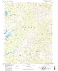
1979 Map of Spicer Meadow Res.
USGS Topo · Published 1984About this map
Stanislaus National Forest defines this high-elevation landscape, where the border between Alpine and Tuolumne counties follows the rugged crests of the Sierra Nevada. In the late 1970s, this area was characterized by a complex network of high-country water storage and recreational points, including the sprawling Spicer Meadow Reservoir and smaller basins like Utica Res and Union Reservoir. The presence of a Gaging Station on the North Fork Stanislaus River and a Boat Ramp at Union Reservoir indicates the management of these glacial valleys for both hydroelectric power and public leisure.
Find a feature on this map
48 named features on this map. Tap any name to fly to it.
Don’t see what you’re looking for? This feature index may not catch every label — zoom into the map to look around manually.
Map Details
Editions of this 1979 Spicer Meadow Res. Map
3 editions found
Other maps of this area

1889 · Pyramid Peak
USGS Topo · 1:125,000

1889 · Markleeville
USGS Topo · 1:125,000

1891 · Markleeville
USGS Topo · 1:125,000

1891 · Big Trees
USGS Topo · 1:125,000

1891 · Pyramid Peak
USGS Topo · 1:125,000

1893 · Markleeville
USGS Topo · 1:125,000

1894 · Big Trees
USGS Topo · 1:125,000

1895 · Pyramid Peak
USGS Topo · 1:125,000

1896 · Dardanelles
USGS Topo · 1:125,000

1896 · Pyramid Peak
USGS Topo · 1:125,000