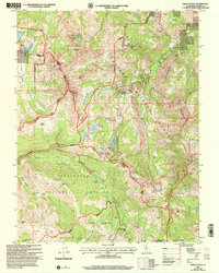
2001 Map of Ebbetts Pass
USGS Topo · Published 2004About this map
Ebbetts Pass serves as the focal point for this high-altitude survey of the Sierra Nevada, marking a critical crossing between the Stanislaus National Forest and Toiyabe National Forest. The map documents a significant history of silver extraction concentrated in the northeast, where the Silver Mountain (Site) and its associated Cem reflect a bygone mining era. Numerous lodes are charted in this vicinity, including the Exchequer Mine, Lady Franklin Mine, and the IXL Mine.
Find a feature on this map
64 named features on this map. Tap any name to fly to it.
Don’t see what you’re looking for? This feature index may not catch every label — zoom into the map to look around manually.
Map Details
Editions of this 2001 Ebbetts Pass Map
2 editions found
Other maps of this area

1889 · Markleeville
USGS Topo · 1:125,000

1891 · Markleeville
USGS Topo · 1:125,000

1893 · Markleeville
USGS Topo · 1:125,000

1896 · Dardanelles
USGS Topo · 1:125,000

1898 · Dardanelles
USGS Topo · 1:125,000

1948 · Walker Lake
USGS Topo · 1:250,000

1956 · Topaz Lake
USGS Topo · 1:62,500

1956 · Markleeville
USGS Topo · 1:62,500

1956 · Dardanelles Cone
USGS Topo · 1:62,500

1956 · Sonora Pass
USGS Topo · 1:62,500