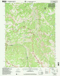
2001 Map of Disaster Peak
USGS Topo · Published 2004About this map
Disaster Peak stands as a prominent sentinel at the heart of the Carson Iceberg Wilderness, marking a high-elevation landscape where the Alpine and Tuolumne County line follows the drainage divides. The terrain is defined by a series of significant summits, including Stanislaus Peak and Boulder Peak, which rise above high-country meadows and alpine water bodies. The Pacific Crest National Scenic Trail winds through this region, following the crest between the Stanislaus National Forest and the Toiyabe National Forest. Notable water features such as Carson Falls and the headwaters of the East Fork Carson River illustrate the hydrology of these protected lands. Unusual geological formations like The Iceberg and Whitecliff Peak provide distinct landmarks for those studying the physical geography of the Sierra Nevada near the turn of the 21st century.
Find a feature on this map
33 named features on this map. Tap any name to fly to it.
Don’t see what you’re looking for? This feature index may not catch every label — zoom into the map to look around manually.
Map Details
Editions of this 2001 Disaster Peak Map
2 editions found
Other maps of this area

1889 · Markleeville
USGS Topo · 1:125,000

1891 · Markleeville
USGS Topo · 1:125,000

1893 · Markleeville
USGS Topo · 1:125,000

1896 · Dardanelles
USGS Topo · 1:125,000

1898 · Dardanelles
USGS Topo · 1:125,000

1948 · Walker Lake
USGS Topo · 1:250,000

1954 · Pickel Meadow
USGS Topo · 1:24,000

1954 · Lost Cannon Peak
USGS Topo · 1:24,000

1956 · Topaz Lake
USGS Topo · 1:62,500

1956 · Markleeville
USGS Topo · 1:62,500